In last week’s blog entry I discussed the cyclical impact of breaches in glacier ice dams on Ice Age climate. The biggest glacial lake in North America formed from rapid melting of glaciers at the end of the last Ice Age is known as Lake Agassiz
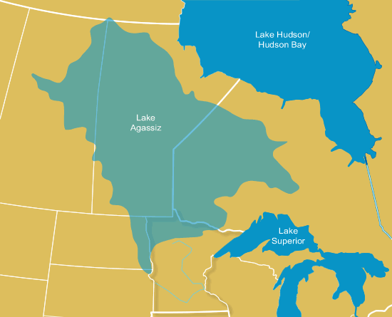
Map of ancient Lake Agassiz. A glacier ice dam formed this lake which existed from ~13,500-~8200 BP.
As the map shows, Lake Agassiz was bigger than all the Great Lakes combined and at the time of its existence was the largest freshwater lake in the world by far. About 12,900 years ago a major breach of the ice dam that formed this lake occurred, flooding the North Atlantic with cold freshwater and shutting down thermohaline circulation (as I described in last week’s blog entry). This event (known as a Heinrich event) triggered a sudden cold snap referred to as the Younger Dryas, named after a species of flower that flourished in Europe during this arid cold phase of climate. The Younger Dryas lasted for 500 years as earth’s temperatures in the northern hemisphere plummetted back to levels equal those of the last glacial maximum (~29,000-~15,000 BP).
As the climate cooled another ice dam formed stopping the outflow of water, so that Lake Agassiz continued to exist. But climate gradually warmed again and the final dissolution of the lake occurred about 8200 BP.
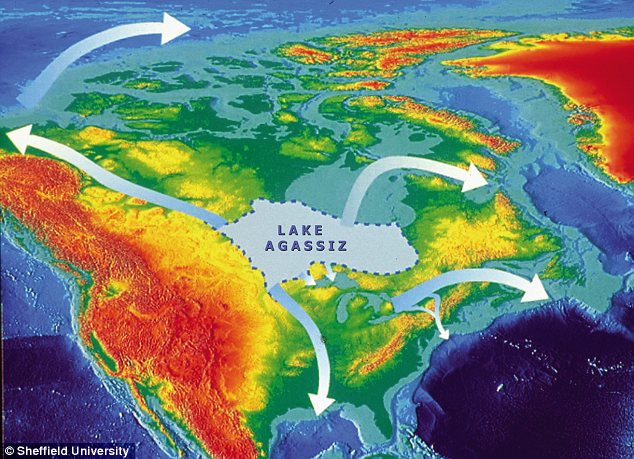
Map showing final outflow of Lake Agassiz. After glacier ice dams broke, the water escaped through tributaries leading to the St. Lawrence River, the Mississippi River, Hudson Bay, and western rivers as well.
The final dissolution of Lake Agassiz also shut down thermohaline circulation, causing a shift in climate to arid and cold, though it wasn’t nearly as severe as the Younger Dryas. Nevertheless, this time, the dissolution of Lake Agassiz was complete, and scientists believe sea levels rose by as much as 1 meter in less than a year. It occurred to me that this closely correlates with the period of time when the Okefenokee basin filled with water and became a swamp. Scientists carbon dating the peat there discovered that the modern version of the Okefenokee became swamp about 7,000 years ago. This is also roughly the time of modern barrier island formation off the Atlantic coast. Between ~36,000 and ~7,000 years BP, the Okefenokee basin consisted of open pine savannah and scrub oak interspersed with small scale streams and freshwater marshes, but an increase in atmospheric moisture and the rise of the water table led to swamp development. It’s likely that swamps periodically developed in the basin and periodically dried out following fluctuations in the water table throughout the Pleistocene.
It’s also been noted that the final dissolution of Lake Agassiz and other glacial lakes all over the world may correlate with worldwide flood myths.

The final dissolution of Lake Agassiz caused sea level to rise by 1 meter in just 1 year. This would have flooded coastal regions.
The literal story of Noah’s flood is impossible, but it may be based on some truth. A flood that covered the entire world is geologically impossible, and there is no scientific evidence to support this belief. But it is likely that the dissolution of Lake Agassiz and glacial lakes in Europe did cause major localized flooding in many areas of the world on a scale far surpassing anything from recent recorded history.
One clue regarding changes in climate patterns resulting from this event comes from Genesis 7:12 in the bible. “It rained for 40 days and 40 nights.” The Little Ice Age, a relatively minor climatic event but one that had a major impact on European agriculture for 500 years (1314-1850 AD) began with cold rainy summers–lots and lots of rain. It’s plausible that the initial flood of freshwater into the North Atlantic caused a low pressure system that drew unusually prolonged spells of cold rain in summer, though, of course, not exactly 40 days in a row. But it wasn’t rain that caused the flooding. Instead, it was the sudden rise in sea level that destroyed coastal villages. Whether or not the villages were morally wicked was coincidental.
Today, Lake Winnipeg and a few other Canadien lakes are remnants of Lake Agassiz. The Great Lakes formed from melted glaciers in ancient river valleys scoured out by glaciers. The Great Lakes formed and reformed many times throughout the Pleistocene, and it’s probable a glacial lake has repeatedly re-occurred on the site of Lake Agassiz as well.
Tags: floody myths, Genesis 7:12, Heinrich Events, Lake Agassiz, Noahs' flood, Okefenokee Swamp, thermohaline circulation

September 28, 2011 at 6:24 pm |
The whole Earth was covered with water at one time. If you don’t believe me read the Bible.
September 28, 2011 at 10:37 pm |
The bible is a document that is full of shit.
May 30, 2012 at 2:06 pm |
[…] water tables across the south rose following the dissolution of glacial Lake Agassiz in Canada (https://markgelbart.wordpress.com/2011/01/06/temporal-correlations-between-lake-agassiz-the-okefenoke…). Mcbean Creek may have sporadically dried up and reappeared in correlation with […]
August 1, 2012 at 1:31 pm |
[…] From ~12,000 BP-at least ~10,000 BP an increase in oak, sedge, and grass suggests a drier warmer climate. The climate became so dry between 10,000 BP-7760 BP that no sediment was deposited and there is no pollen record for that time period here. Since ~7760 BP the modern composition of plants as discussed in the first paragraph of this essay has predominated. Climate has changed little over the past 7700 years following the final dissolution of the massive glacial Lake Agassiz in Canada…at least in comparison with Ice Age climate fluctuations. (See also https://markgelbart.wordpress.com/2011/01/06/temporal-correlations-between-lake-agassiz-the-okefenoke…) […]